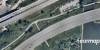
Historical aerial archives directly in JMAP
About K2 Geospatial
Since 1995, K2 Geospatial has been designing solutions that enable users to access and visualize geospatial data to support informed decision-making. Its JMAP platform is used by hundreds of organizations to connect, integrate, and leverage their spatial data efficiently.
An integration that enhances data discoverability for municipalities and territorial organizations
Geoselec and K2 Geospatial are proud to announce a strategic collaboration that now allows JMAP users to directly access Geoselec’s catalog of historical aerial photographs through a built-in extension. Thanks to this 100% locally developed geospatial innovation, territory managers (cities, regional county municipalities) gain efficiency and access to a valuable heritage resource for understanding territorial evolution.
Added value for JMAP clients
-
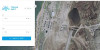
Immediate access to the Geoselec catalog and metadata — without leaving JMAP
-
Quick polygon-based search
-
Historical context to support planning decisions
-
Image preview and pre-selection for orders or historical orthomosaic projects (Geoselec Parallel Program)
-
Sustainable integration with continuous catalog updates
Use cases
-
Territorial evolution analysis (urban expansion, brownfields)
-
Environmental studies (wetlands, coastal erosion)
-
Municipal asset management (right-of-way, easements, infrastructure)
-
Historical validation in engineering (bridges, roads, dikes)
-
Legal support (acquired rights, land disputes)
Testimonials
“With the integration of Geoselec into JMAP, we’re offering our clients unique access to the territory’s history — directly within their workspace.”
— Jacques Charron, CEO, K2 Geospatial
“This collaboration perfectly illustrates the strength of Québec’s geospatial partnerships: agility and territorial intelligence.”
— Geneviève Grenier, President and CEO, Geoselec